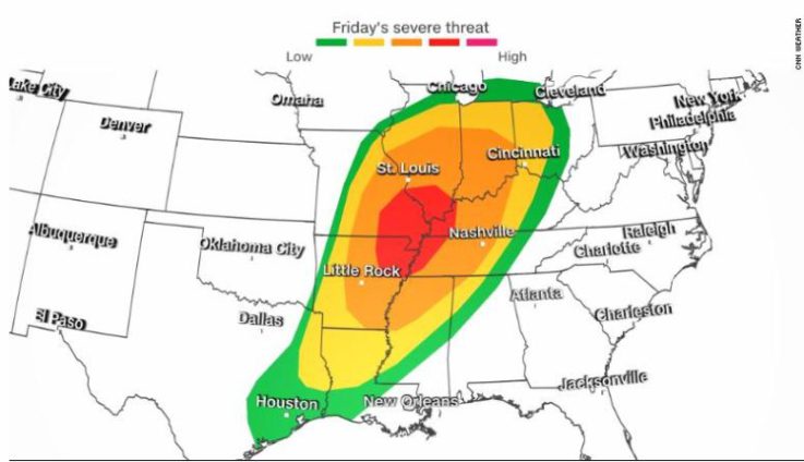
A powerful storm raced across the central US late Friday, unleashing at least 14 tornadoes in five states.
One person were killed and several injured in Monette, Arkansas, after a tornado struck a nursing home, according to Craighead County Judge Marvin Day.
Local officials had previously said two people died, but Day said the local coroner has since determined there was only one death.
"Everyone has been taken out of the nursing home and is accounted for," the town's mayor Bob Blankenship said. "We have a triage center set up at the local school where people are being treated and others have been transported to local hospitals."
In Tennessee, several structures were damaged and an unknown number of people were trapped in Samburg, according to Union City Police Chief Karl Ullrich. Samburg is in the northwest portion of the state, north of Memphis.
"It's just a small community. It's pretty well flattened," Obion County Sheriff's Office Dispatcher Judy Faulkner told CNN.
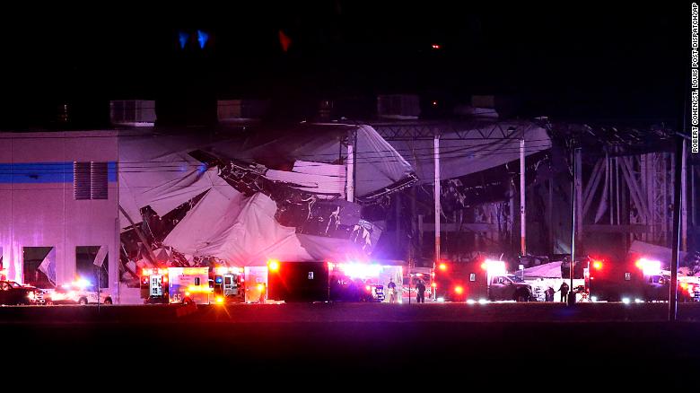
In Illinois, an Amazon warehouse was damaged in Edwardsville, which is 24 miles east of St. Louis, Missouri.
Law enforcement did not immediately have details about how badly the building was damaged, but Ayesha White told CNN affiliate KMOV that a family member is an employee who was trapped inside.
"They were actually calm. They were just trying to figure out how to get out," White said. Video from the scene showed a large emergency response.
Illinois Gov. JB Pritzker said he'd reached out to the Edwardsville mayor to offer assistance.
"My prayers are with the people of Edwardsville tonight, and I've reached out to the mayor to provide any needed state resources. Our @ILStatePolice and @ReadyIllinois are both coordinating closely with local officials, and I will continue to monitor the situation," the governor said in a tweet.
My prayers are with the people of Edwardsville tonight, and I've reached out to the mayor to provide any needed state resources.
— Governor JB Pritzker (@GovPritzker) December 11, 2021
Our @ILStatePolice and @ReadyIllinois are both coordinating closely with local officials and I will continue to monitor the situation.
Tornadoes were reported in Arkansas, Missouri, Tennessee, Kentucky and Illinois, according to the National Oceanic and Atmospheric Administration's Storm Prediction Center.
Overall, more than 55 million people nationwide were at risk for severe storms Friday.
"This dynamic, sprawling storm will impact more than half the country. It's a classic clash of air masses," said CNN meteorologist Gene Norman.
As cold, arctic air surges south it will clash with record warm and humid air in place across the South, sparking severe storms where the air masses meet.
Earlier, tornado watches were issued for central and eastern Arkansas, southeastern Missouri, northwestern Mississippi, western Tennessee, western Kentucky, southern Illinois and southwestern Indiana, according to the Storm Prediction Center.
The watch is in effect until 11 p.m. CST and includes Memphis, Tennessee; Little Rock, Arkansas; Paducah, Kentucky; and Evansville, Indiana.
Strong thunderstorms are expected to develop with storm coverage increasing through the evening. In addition to tornadoes, wind gusts up to 75 mph and hail up to 2 inches in diameter are also possible.
A second tornado watch was issued Friday evening for portions of Missouri and Illinois. The watch is also in effect until 11 p.m. CST and includes St. Louis, Jefferson City and Springfield in Missouri and Springfield and Quincy in Illinois.
By mid-evening Friday, five tornado watches stretched from northeastern Texas and eastern Oklahoma to central Tennessee and Kentucky.
One of the newest watches includes Nashville and Louisville, Kentucky, and is in effect until 2 a.m. CST.A moderate risk of severe storms -- level 4 out of 5 -- has been issued for over 2 million people, including in the city of Memphis, by the Storm Prediction Center.
This area has the greatest probability of strong EF2-EF5 tornadoes with winds of at least 111 mph or higher possible.The last time there was a moderate risk of severe storms issued in December was December 16, 2019.
An enhanced risk -- level 3 -- surrounds this moderate risk zone and covers major cities like Indianapolis, Nashville, St. Louis, Missouri, and Louisville, Kentucky.
Meanwhile, a slight risk -- level 2 -- of severe storms encompasses the enhanced risk area and extends from eastern Texas through northern Indiana. There is also a marginal risk -- level 1 -- of severe storms that stretches from the Gulf Coast of Texas to the Great Lakes.
"The main concerns will be for occasional tornadoes (some potentially capable of EF2+ damage) and scattered, damaging thunderstorm gusts," the prediction center said Friday morning.
"Though late-afternoon development near the front is possible, the overwhelming majority of strong-severe convection should be after dark."
Severe storms developing after dark pose a significant threat for nighttime tornadoes to occur, some of which may be strong, according to prediction center.
"Nighttime tornadoes are statistically more than twice as deadly as day time storms," CNN meteorologist Dave Hennen said.
Southern states including Tennessee, Kentucky and Arkansas experience more overnight tornadoes than any other region. This can lead to higher fatalities, since many people are sleeping and unaware that a tornado is approaching.
This is why it is important to have an alert system such as a weather radio or an app on your phone that can wake you up if a tornado watch or warning is issued for your area.
Winter returns for a large section of the US
On the northern part of this system, snow will blanket a large part of the country from the Intermountain West to the Upper Great Lakes through Saturday. Over 10 million Americans are under some form of winter weather alerts from this system.
The Minnesota State Patrol responded to 136 crashes prior to 4 p.m. on Friday, according to a tweet by the agency. Eight of those accidents were jackknifed semi-trucks. Thirteen were injury accidents.The Twin Cities area is currently under a snow emergency.

Light snow fell Friday morning at Denver's International Airport, meaning the area finally recorded its first measurable snow of the season, defined as a 10th of an inch or greater.
This brings an end to the record snow drought the city had been experiencing. Since 1882, the city had never made it into December without measurable snow. The previous record for latest measurable snow was November 21, 1934.
The city also went 232 consecutive days without measurable snow, the second-longest streak in recorded history. The record is 235 days: from March 5 to October 25, 1887.
The snow is expected to be light in Denver, with the forecast calling for around 1 inch of accumulation today, with higher tallies in the mountains to the West.
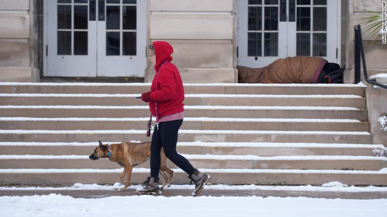
Elsewhere, many motorists will be forced to test their winter driving skills for the first time this season as conditions quickly deteriorate under a band of heavy snow from Cheyenne, Wyoming, to Marquette, Michigan.
"Given this is the first widespread and significant snowfall of the season, residents in these areas are urged to plan ahead and take proper precautions if venturing out into the storm," explained the prediction center.
Snowfall rates of 1 to 2 inches per hour are possible tonight into Saturday morning across a large stretch of the Upper Midwest and Great Lakes region.
A widespread area of 6 inches of snow is anticipated, with up to a foot possible where the center of the low-pressure system pivots and dumps the heaviest snowfall. This area includes southern Minnesota, northern Wisconsin and portions of Michigan's Upper Peninsula.
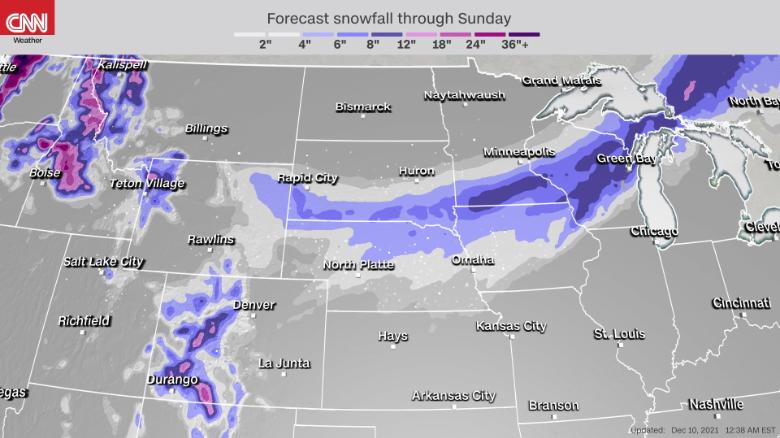
Heavy snow will be accompanied by strong gusty winds that will make travel conditions extremely difficult.
Blowing snow from winds gusting over 50 mph will reduce visibilities and create slick roads from the Central Plains to the Upper Great Lakes. Potential travel impacts could be greatest across the heavily traversed Interstate 90 corridor.
High winds expected behind system
As the storm pushed east late Friday, it was expected to intensify.
A High Wind Watch was in effect from Saturday morning through Saturday evening for much of southern Michigan, including Detroit, where southwest winds of 20 to 30 mph with gusts into up to 60 mph are possible.This could lead to downed trees and power lines.
"Widespread power outages are possible," the weather service warns.
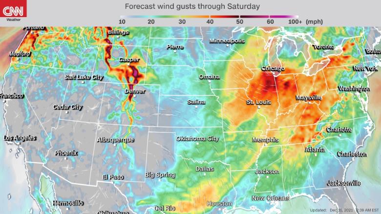
Those high winds will also impact areas in and around Lake Michigan, including Chicago, as a gale watch remains in effect from late Friday night through Saturday afternoon.
As the storm moves across the area, northwest winds of 25 to 35 knots are expected with gusts up to 45 knots along with 6- to 13-foot waves.
Latest Stories
-
Nigerians mourn woman allegedly beheaded by gospel singer
11 minutes -
Sudan shelling kills more than 100 civilians near capital
18 minutes -
Mahama hits the ground running: Key reforms and directives in first days of office
23 minutes -
Relatives wait for news as body bags hauled from South African mine
30 minutes -
Kate reveals she is in remission from cancer
50 minutes -
UK’s Treasury minister resigns over anti-corruption investigation in Bangladesh
1 hour -
Fire Service calls for installation of fire extinguishers, detectors at marketplaces
1 hour -
Kofi Adu Domfeh: Prayers for rain in LA and the call for climate action
1 hour -
Don’t appoint Bawku or Kusasi native as U/E Regional Minister – Asamoah Boateng advises Mahama on averting dispute
1 hour -
Bono COCOBOD seizes trucks loaded with bags of cocoa, lumber
2 hours -
Recent Appointment Committees have become a theatre – Draman
2 hours -
Mahama appoints Justina Nelson as Acting CEO of MIIF
2 hours -
Tribunal system was evil, why does Mahama gov’t want it back? – Ansa-Asare
3 hours -
Kurt Okraku files nomination for CAF Executive Committee position
3 hours -
Criminologist urges police to engage communities to prevent attacks on security personnel
4 hours

